Lake Malawi cichlids — species, locations & maps
Lake Malawi cichlids — species, locations & maps
By genera
By locations
Locations
Maps
Posters
Interactive map
Search
×
Copy link
Share
Facebook
Shire River, Lake Malawi, Malawi
Photo gallery
Shire River
Photo: © Ad Konings
The upper Shire River (only river draining Lake Malawi), looking south toward Mangochi and Lake Malombe
(a sliver of which is seen at upper right), on flight from Mangochi to Monkey Bay. 26-April-1971
Photo: © Michael K. Oliver
Shortly after takeoff from Fort Johnston (now Mangochi). Upper Shire River, looking south to Lake Malombe. 26 April 1971
Photo: © Michael K. Oliver
Inflow of upper Shire River into Lake Malombe from the Islander. 26-April-1971
Photo: © Michael K. Oliver
This is the south end of Lake Malombe, with its outflow at right into the Middle Shire River, Malawi. Looking ENE.
Note the beach ridges along the near shore. 26-April-1971
Photo: © Michael K. Oliver
Wash day along the Shire River in southern Malawi, 1968. Looks like a good spot for crocodiles to lurk.
There's a river depth gauge at right, marked from 11 to 15 feet.
Photo: © Michael K. Oliver
The Kamuzu Barrage at Liwonde on the upper Shire River, south of Lake Malombe and just south of Liwonde National Park.
Looking southwest; upstream to the left. This bridge and barrage, built in the 1960s, was intended to control the level of Lake Malawi
and regulate the flow rate of the river. Now cracking and felt by the local people to be dangerous.
Photo: © Michael K. Oliver
malawi.si
Lake Malawi cichlids — species, locations & maps.
All images are used with permission of the authors. Unauthorized use is prohibited.
Quick links
By genera
By locations
Locations
Maps
Posters
Interactive map
Contact
Support this site
© malawi.si
◀
▶

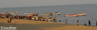
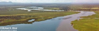
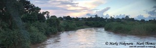

Photo gallery
Photo: © Ad Konings
(a sliver of which is seen at upper right), on flight from Mangochi to Monkey Bay. 26-April-1971
Photo: © Michael K. Oliver
Photo: © Michael K. Oliver
Photo: © Michael K. Oliver
Note the beach ridges along the near shore. 26-April-1971
Photo: © Michael K. Oliver
There's a river depth gauge at right, marked from 11 to 15 feet.
Photo: © Michael K. Oliver
Looking southwest; upstream to the left. This bridge and barrage, built in the 1960s, was intended to control the level of Lake Malawi
and regulate the flow rate of the river. Now cracking and felt by the local people to be dangerous.
Photo: © Michael K. Oliver